
Top 10 iPhone Hiking Apps
When you go for a hike nowadays you most probably will be taking your iPhone with you. To make the activity even more eventful, make sure you have one, or perhaps several of these absolutely excellent hiking apps on your device. Just take a look at these…
i.Walk – GPS Fitness Coach for Hiking and Weight Loss
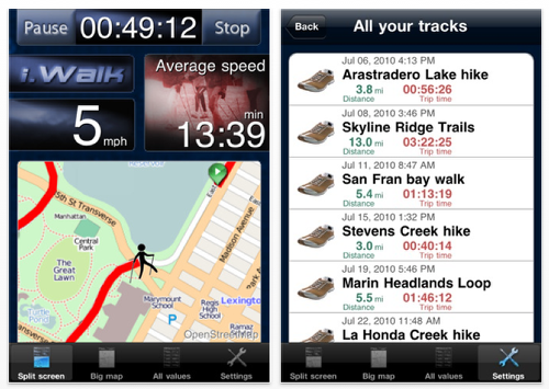
– Accurate values for speed, pace per mile, average per mile, record per mile, distance, current altitude, burned calories as well as trip time. Units can be set to US or metric.
– Watch yourself automatically move on the map and zoom in on your walk with mile markers (red line)
– Receive your trips via email (KML und GPX) and review them at home (e.g., with Google Earth) or share them with other walkers. You can send the data after each ride or anytime later from your track history (e.g. when there is no cellular network available). For detailed analysis of your trips at home we recommend to upload your tracks to the portal www.1-2-sports.com at no charge.
– Suspend, pause, and resume for receiving calls or when you need to take a break
– iPod function can be used together with i.Walk
Based on countless tests and refinement we calculate all values with maximum precision of the built in GPS. It just works – out of the box.
Camp Recipes!
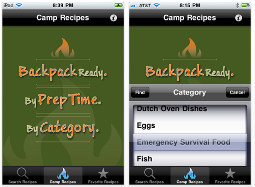
Camping never tasted so Good! Whatever you can think of to cook on a campfire, this app has 10 ways to cook it. And they aren’t just made up either….these are campers’ favorite recipes from all over the country, tried and true, cooked and eaten. With over 700+ recipes conveniently listed by category, by time, and by keyword search, you can literally go on 100’s of campouts and hike’s without eating the same thing twice. This is the most comprehensive camping recipe app on the market!!
Quick recipes, long recipes, backpack recipes, large recipes, meat recipes, veggie recipes, dessert recipes, and even survival recipes! And that’s just a few. You just have to search it, tap it, and there’s the ingredients and all the instructions how to prepare and eat.
Chimani Acadia National Park
+ Content has been written by a professional travel writer – not copy-and-pasted from the Park Service website!
+ Over 100 professional photographs of park.
+ Descriptions for 45 of the most popular hiking trails with the park.
+ Unique Safety section which details all the concerns while visiting the park.
+ Location and description of EVERY restroom in the park!
+ Location and description of EVERY parking lot in the park!
+ Location and description of EVERY picnic area lot in the park!
+ Over a years worth of tidal data (high/low tide) for the Park.
+ Over a years worth of sunrise/sunset data for the Park.
+ Details on bicycling, camping, lighthouses, museums, swimming, birding and boat launches throughout the park!
iMapMyHIKE – Hiking, Trail Running, Camping, GPS
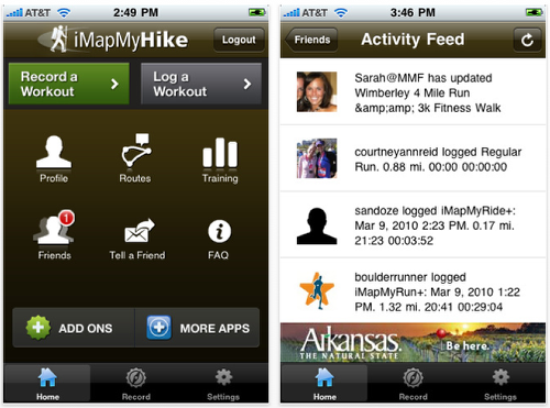
iMapMyHIKE uses the built-in GPS technology of your iPhone to enable you to track your hikes and gets you closer to achieving your health and fitness goals. Step out your front door, hit the trail, and this app will effortlessly mark out your path along an interactive map and record essential metrics including duration, distance, pace, speed and elevation. Once you finish your hike, save your data and it automatically uploads to MapMyHIKE.com where you can view your route, hike data, and a comprehensive workout history. Plus, the new iMapMyHIKE gives you the ability to easily share your hike data with friends and family via email and Twitter.
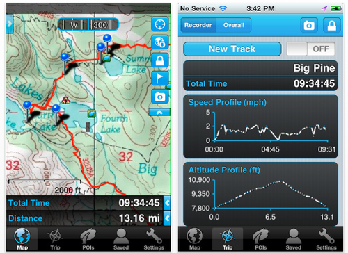
MotionX GPS
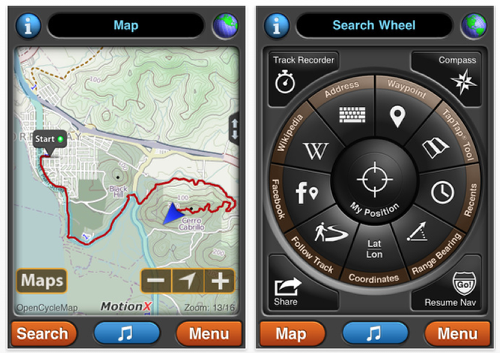
▶ MotionX-GPS is for your outdoor life: Walking, Hiking, Running, Cycling, Biking, Sailing, Skiing, Flying, Racing, Geocaching.
▶ MotionX-GPS shows your position and track at all times on street maps, topo/terrain maps, satellite/hybrid maps, or marine charts. Record or follow your tracks and share with a single click your position, track, trip statistics (date, start time, elapsed time, distance traveled, average speed, etc.) and a picture taken along the way.
▶ Free downloadable maps worldwide! Including MotionX Road and Terrain maps, and NOAA marine charts.
▶ MotionX-GPS is the leading GPS solution for the iPhone, with over 5 million happy users. Exclusively designed and optimized for the iPhone.
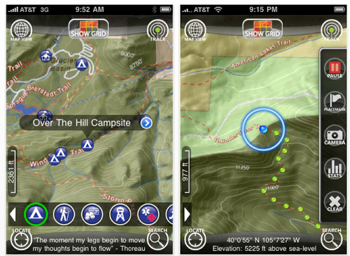
Gaia GPS – Offline Topo Maps, Compass, and GPS Tracking for Trails – Hiking, Biking, Skiing, Camping, Running
Off-trail, road-tripping, or wandering abroad? Use Gaia GPS to navigate anywhere you aren’t connected.
Gaia GPS is a full-featured outdoor GPS app, developed by Anna and Andrew. We wander around with our dogs and like to pitch our tent wherever Gaia leads us. Please email us with questions, bug reports, feature ideas, and other feedback at gaia@gaiagps.com.
Gaia lets you:
• Download maps for times when you don’t have an internet connection.
• View topographic and road maps. Use MyTopo maps in the US/Canada, and Cloudmade topo and road maps all over the world.
• Record tracks, waypoints, and take geo-tagged photos.
• Search for nearby waypoints and reports about places.
• Import and export GPX files, by email or to EveryTrail.com.
• Customize all aspects of Gaia, including units, coordinates types, color and sound, and more.
• Browse the Map Store, and subscribe to cool map sources like Snowmobile Trails from US Trailmaps, NOAA Charts, and more.
Topo Maps
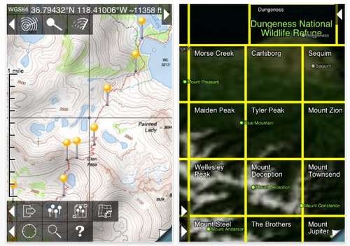
★ View USGS 1:24,000 topographical maps on your iPhone or iPod touch. ★ Ideal for hiking and other backcountry activities. ★ Map downloads are FREE! ★ Provides more than 69,000 maps covering the United States and Canada, including Alaska, Hawaii, Puerto Rico and the U.S. Virgin Islands.
The Maps: these USGS and NRCan maps are the definitive resource for hikers and other backcountry users, and the scans used by this app are of the highest quality. You can make the terrain stand out with hill shading, using simulated sunlight from the direction of your choice.
Downloading: US maps are around 8 MB in size and download in around 10 seconds to 2 minutes on a typical home broadband connection. About 15% of maps then require a 3-minute installation process. Canadian maps are larger. Both cellular data and WiFi can be used, though WiFi is likely to be more reliable in most cases. Please get in touch if you encounter problems while downloading maps.
Maplets — Maps for National Parks, Subway, Ski Resorts and more
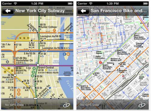
The most comprehensive map app on the app store, with 4000 maps in the US and worldwide including Yosemite, New York Subway, London Tube, Yellowstone, Grand Canyon, State Parks, and more.
Maplets is the perfect compliment to Google Maps: You can download and store maps of national parks, state parks, metro, subway, bike maps, ski resorts, college campuses, zoos, theme parks and more!
You do not need to purchase the more specific maplets apps such as Bike Maps or Metro Maps if you already own the full version.
AccuTerra Unlimited – Maps & GPS Tracker: Trails to Hike, Run, Bike, Ski
AccuTerra UNLIMITED is is your one-stop GPS outdoor recreation app, with over five million square miles of terrain and trail maps – designed specifically for the iPhone. These are not shrunken USGS maps that were made to print in 2 foot paper sheets; AccuTerra HD maps are TRIPLE the zoom level and contain the most recent trail and public land data available, optimized for your iPhone. Comparable recreation maps for expensive dedicated GPS units can cost hundreds in additional fees – AccuTerra UNLIMITED gives you all this for ONE LOW PRICE. (Not sure? Try AccuTerra On-Demand for a complimentary map trial.)
Maps are quickly downloaded and stored into the device’s memory – select On-Demand mode to get 50 square miles at a time, or choose from over 350 defined recreation areas in the AccuTerra catalog. Once your maps are loaded, AccuTerra provides an accurate GPS location, on beautiful color maps, wherever you have clear line of sight to the sky…even if you’re hundreds of miles from the nearest cell signal. Choose from over 220,000 miles of trails, thousands of trailheads, campgrounds, picnic areas — it’s the ONLY app available that displays all major public land boundaries.
Trails
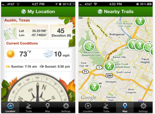
Are you looking for the perfect hiking trail? Do you need a virtual compass to help navigate directions? Now you can view professional, high quality trail guides on-the-go!
The Trails.com app offers over 48,000 trail guides from the top outdoor publishers. Trail guides cover over twenty-four different outdoor activities including everything from mountain bike trails to off-road trails. You can search trails nearby, view details of specific trails and even get up-to-date weather conditions to ensure a quality outdoor experience.
Features:
· Ability to log in & gain unlimited access to all trail guides (requires a paid Trails.com subscription)
· Up-to-date weather conditions, elevation, gps location and time of sunrise/sunset of your current location
· Virtual compass for easy navigation
· Ability to search all trail types in any specific region
· Find places to hike, bike and other outdoor activities near you
· View specific details on all trails (includes trail type, distance, duration, elevation & skill level)
· Check out the current conditions of any trail
· Save your favorite trails for future reference
· View the map with all nearby trails icons for each specific activity
· Ability to view trail guides by region
Joanne Carter
Joanne Carter is a British photography journalist, editor, curator, and the founder of *TheAppWhisperer.com*, one of the world’s leading platforms dedicated to mobile photography and art. Since its launch in 2009, TheAppWhisperer has become an international hub for artists of all levels to discover, learn, exhibit, and engage with contemporary photographic practice.Built on principles of inclusivity, accessibility, and artistic excellence, Joanne has spent almost two decades championing mobile photography as a serious artistic medium. Through interviews, critical essays, exhibitions, competitions, and education, she has helped shape and document the evolution of mobile art on a global scale.Her work has taken her internationally, lecturing on photography and mobile art at institutions and events including the Museum of Art in Seoul, South Korea, alongside appearances in the UK and Europe. She has served as a juror for international photography and mobile art awards across Portugal, Canada, the United States, South Korea, Italy, and the UK.Joanne is also the founder of *TheAppWhispererPrintSales.com*, one of the first online galleries dedicated exclusively to collectible mobile art, connecting artists with collectors across Europe, the United States, and Asia.Before founding TheAppWhisperer, Joanne worked extensively in print journalism and photographic publishing, including roles at a paparazzi photo agency and as deputy editor of a leading photography magazine. Her freelance journalism, criticism, and commentary have been published widely in both the UK and the US, with bylines in *The Times*, *The Sunday Times*, *The Guardian*, *Popular Photography*, *NikonPro*, *DPReview*, *Which?*, *Vogue Italia*, *LensCulture*, the *BBC*, and more recently, the *Financial Times*, where her published letters on photography continue to contribute to wider conversations around the medium.Alongside her editorial and curatorial work, Joanne’s own photographic practice has been exhibited internationally across the UK, Europe, South Korea, and the United States. Her work increasingly explores themes of grief, loss, death, memory, and the body.Her current research interests centre on grief, death, and poverty, with forthcoming postgraduate study leading towards doctoral research in these areas.Joanne is currently developing new long-form writing and photographic projects and is available for commissions, editorial projects, speaking engagements, and collaborations.Contact: joannetheappwhisperer@gmail.com)


2 Comments
alex van der kleij
Now available in the AppStore : iShouldMove
Imagine you are skiing, biking or hiking all alone, suddenly you fall and can not move.
Who will call for help?
Your iPhone will do this, when you are running iShouldMove.
When it’s triggered a message with your GPS location is sent to a selected recipient.
This can be done with a single button press or even better, all in background.
All sent messages are normally stored and visible in your messaging system and lists.
Link : http://itunes.apple.com/us/app/ishouldmove/id499969683?l=nl&ls=1&mt=8
TheNavApper
A sighting compass is always good when hiking. This one uses iPhones camera augmented with a compass. http://www.lndqvst.se/lndqvst/onSight.html